Skip to content

UW Roundtable on the Frontiers of Geospatial Artificial Intelligence

Greetings, GIScientists, Geographers, and Computer Scientists at UW,

Please join us at SMI 415c on Monday, October 31st at 4:30 p.m. for a Roundtable Seminar on the Frontiers of Geospatial Artificial Intelligence (GeoAI) organized by the Humanistic GIS Lab of the Department of Geography. The invited speakers will discuss their recent projects, including
    • Revealing the Flow Patterns Underlying Spatial Distribution SnapshotsDi Zhu, Dept of Geography, Environment, and Society at the University of Minnesota, Twin Cities;
    • Towards a Foundation Model for Geospatial Artificial Intelligence, Gengchen Mai, Dept of Geography, the University of Georgia;
    • Trajectory Privacy Protection with Geospatial Artificial IntelligenceJinmeng Rao, Dept of Geography, University of Wisconsin-Madison and Google [X]; and
  • An Initial Investigation of Geographical Misinformation: Rethinking Satellite Imagery Authenticity and TrustworthinessYifan Sun and Bo Zhao, University of Washington, Seattle.
Please forward this email to anyone who might be interested in this seminar. If you have any questions, feel free to contact Bo Zhao at zhaobo@uw.edu.
=====Biosketch of the speakers========
Dr. Di Zhu is an Assistant Professor of Geographic Information Science in the Department of Geography, Environment, and Society at the University of Minnesota, Twin Cities (UMN), a faculty member of the Minnesota Population Center (MPC), an executive committee member of the MGIS program at UMN, and the director of Geospatial Data Intelligence (GeoDI) Lab. Prof. Zhu holds a Ph.D. in Cartology and GIScience from Peking University (PKU), a B.S. in Geographic Information Systems and a dual B.S. in Economics both from PKU. Prof. Zhu’s research aims at generating both theoretical and actionable insights from spatiotemporal data by exploring the frontiers that bridge geospatial analysis, artificial intelligence, and social sensing. He uses integrated spatial thinking and cross-disciplinary methods to facilitate Intelligent Spatial Analytics (ISA) and Geographic Knowledge Discovery, focusing on the human-environment complexities within the population, urban dynamics, public health, human mobility, spatial networks, socioeconomic sustainability, crime, business optimization, etc. He has published more than 30 articles in top-level peer-reviewed academic journals and conference proceedings, including the International Journal of Geographical Information Science, Annals of the American Association of Geographers, GeoInformatica, ISPRS Journal of Photogrammetry and Remote Sensing, Proceedings of the ACM SIGKDD International Conference on Knowledge Discovery & Data Mining, etc. He is a reviewer for over 25 journals and book publishers. He also serves as the guest editor in journals such as Frontiers in Environmental Science, Sustainable Cities and Society, and Remote Sensing. He is currently directing the Faculty Interactive Research Program (FIRP) grant project subsidized by the Center for Urban & Regional Affairs (CURA) in Minnesota. He has won academic accolades such as the Rising Star Award of College GIS Forum in China, the Tang Lixin Scholarship, Distinction of Doctoral Thesis of Peking University, and the Early Career Award of GIS Research of the United Kingdom.
Dr. Mai Gengchen is an Assistant Professor at the Department of Geography, University of Georgia, and an Affiliated Professor and Graduate Program faculty of the UGA Computer Science Department as well as the UGA Institute for Artificial Intelligence. Before he came to UGA, Dr. Mai was a Postdoctoral scholar at Stanford Artificial Intelligence Laboratory (SAIL), Department of Computer Science, Stanford University. Dr. Mai got his Ph.D. in Geographic Information Science from the Department of Geography, University of California, Santa Barbara, in 2021. His research mainly focuses on Spatially Explicit Artificial Intelligence, GeoAI, Geospatial Knowledge Graph, Deep Learning on Remote Sensing, and Computational Sustainability. Until now, Dr. Mai has published 52 peer-reviewed scientific publications in top international journals and CS/GIS conferences. He is the winner of 3 best paper awards (AGILE 2019, ACM K-CAP 2019 & 2021), and the recipient of various scholarships, fellowships, and grants, such as the Top 10 WGDC 2022 Global Young Scientist Award, AAG 2022 William L. Garrison Award for Best Dissertation in Computational Geography, The Jack and Laura Dangermond Graduate Fellowship, UCSB Schmidt Fellowship, Microsoft AI for Earth Grant, and so on.
Jinmeng Rao is an ABD in Geospatial Data Science Lab at the Department of Geography, the University of Wisconsin-Madison, supervised by Prof. Song Gao. He also works as a Research Scientist at X, the Moonshot Factory (formerly Google[X]). He holds a Master’s degree in Computer Sciences from UW-Madison, a Master’s degree in Cartography and Geographic Information Systems from Wuhan University, and a Bachelor’s degree in Geographic Information Systems from Wuhan University. His main research interests include Geospatial Artificial Intelligence (GeoAI) and its application in geoprivacy protection. He published over 20 academic articles in peer-reviewed journals and conferences, including Transactions in GIS (TGIS), Computers, Environment and Urban Systems (CEUS), GIScience, etc. He also serves as a reviewer for over 10 academic journals, including Scientific Reports, TGIS, Computers & Geosciences, etc. He is the recipient of various awards, including national/university-level scholarships. He served as the student director for the Geographic Information Science and Systems (GISS) Specialty Group of the American Association of Geographers (AAG), and he is a volunteer for several international programs and conferences, including AAG Annual Meeting, ERASMUS, UN Mappers, Wisconsin Land Information Association (WLIA), and CPGIS. He co-founded the GISphere project that collects timely and comprehensive information on global graduate programs and opportunities in Geographic Information Science (GIS) and related fields.
Yifan Sun is a third-year Ph.D. student in the Department of Geography at the University of Washington (UW), in Seattle. He has a background in Geographical Information Science, Urban Planning, and Computer/Data Science and used to work for Bytedance as a full-stack data scientist. His doctoral research is about geographical misinformation, especially focusing on satellite imagery.
Dr. Bo Zhao is an Associate Professor in the Department of Geography at the University of Washington (UW) in Seattle, where he also directs the Humanistic GIS Laboratory (HGIS Lab). Prior to his position at UW, Bo was Assistant Professor at Oregon State University after completing a Postdoc at the Harvard Kennedy School of Government. Bo’s research lies at the intersection of GIScience and Human Geography. He has developed a uniquely humanistic approach to examining GIScience and technologies, especially for the interests of vulnerable populations, such as refugees displaced by climate change effects or LGBTQ+ communities in repressive national contexts. Bo studies how geospatial data streams from social media are used in high-profile social and political struggles, looking, for instance, at “location-spoofing” by activists—like indigenous groups involved in territorial struggles—or by reactionary groups agitating over “fake news.” His recent work on deepfake geography urges GIScientists to develop coping strategies to the ambivalent nature of GeoAI in the age of “post-truth.” The research framework of his recent studies has been funded by NSF, NIH, National Geographic, Samsung, and Google.

Celebrate GIS DAY 2020 at UW!

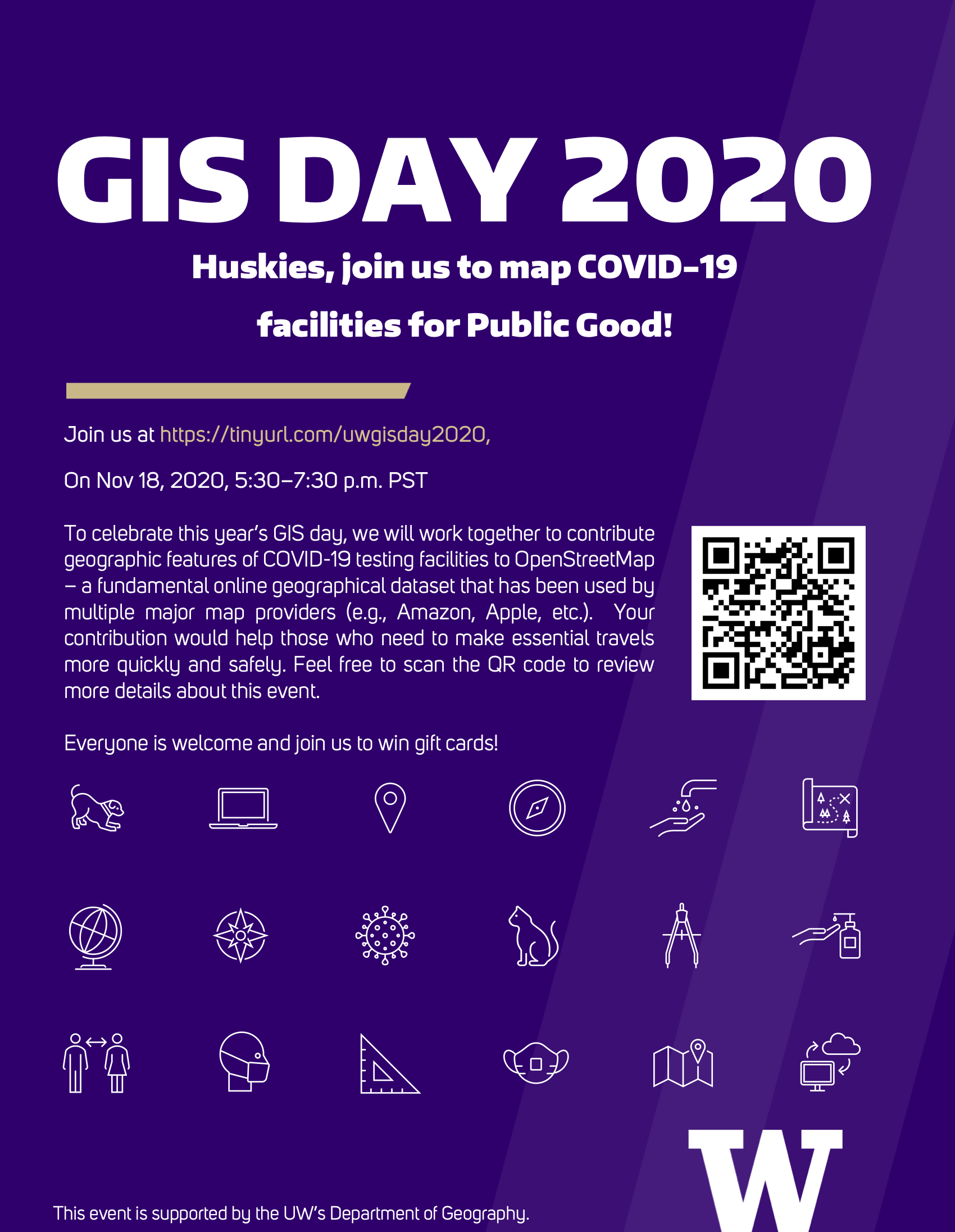
The 22nd GIS Day is coming on November 18th, 2020! Initialized by Esri in 1999, GIS Day is an annual event celebrating the wide use of GIS. On this day, celebrating events will be held by geographers and GIS lovers all over the world.

This year, UW’s Department of Geography will hold an event encouraging people to contribute geographic features of COVID-19 facilities to OpenStreetMap (OSM), the most famous community-based map service in the world. As a free editable map, OSM offers everyone a chance to be a map-maker by allowing users to contribute to the map contents in a timely manner. OSM has been adopted by many big companies including Apple, Amazon, Microsoft, and Facebook, which means that the crowdsourced data will benefit not only the direct end-users of OSM but also many other users who indirectly use the information from OSM. During this special time of the COVID-19 global pandemic, contributing detailed and up-to-date information to OSM will help those who need to make essential travels complete their trips more quickly and safely, thereby helping flatten the curve.

During the event, a workshop on how to contribute geographical data to OSM will be offered (the workshop material can be found here), and then the participants will contribute COVID-19 relevant public health facilities to OSM. We also prepared prizes for those who make substantial contributions – we have three $50 Amazon Gift Cards for the top 3 contributors in our event.

Please register at https://tinyurl.com/uwgisday2020 and join us on November 18th!

Humanistic GIS Laboratory Recruitment 2020-2021

Looking to get more involved on campus? Seeking to explore careers and passions? Read on for exciting opportunities and helpful resources at the Humanistic GIS Laboratory (refer to https://hgis.uw.edu)!

This Lab is committed to exploring the Digital Earth as the home of humankind.  Driven by this common interest, a group of UW scholars and student researchers have been working together (1) to explore innovative methodologies to improve geospatial technologies with the consideration of human experience,  (2) to reflect upon the social implications of maps, geovisualization, and other geospatial technologies, and (3) to geo-narrate a variety of geographic phenomena, especially those related to vulnerable populations. Up to now, multiple Projects have been funded by the National Science Foundation (NSF), National Institutes of Health (NIH), National Geographic, and Google. Below are some featured projects that have been done by HGIS Lab.

Professor Bo Zhao has announced an opportunity for undergraduate students to get involved in some very high-level research projects related to Data Science and Web GIS, the specific projects include, but not limited to, Web Mapping (related to COVID-19, LGBTQ+ spaces, coastal resilience), Point Cloud Visualization, GeoBlockchain for the Vulnerable, and UI/UX Design. We are seeking students who are motivated and willing to! If you are seeking to gain experience with data science and web mapping/web development, our lab is a perfect place for you!

Requirements:

  • A current undergraduate student at the University of Washington;
  • Must have the self-motivation to learn new technologies, software, methodologies and assist the team to operate at maximum efficiency; and
  • Great communication skills and teamwork ethics.

Preferred skills (not required):

  • Demonstrated proficiency in data analysis and point cloud visualization;
  • Familiarity with the programming language such as JavaScript, Python; and
  • Prior experience with website design and web mapping development.

Student volunteers are expected to work at least 3 hours per week. The professor/supervisor will provide necessary guidance related to lab projects. Volunteer can become a former lab member if being nominated by a current lab member. In the past year, most of the former lab members have been 1) admitted to graduate school, 2) got industrial internships or 3) were funded by very high-grade research grants from NSF, NIH or UW. Therefore, if you are interested in this opportunity, please email a short paragraph to Dr. Bo Zhao via zhaobo@uw.edu about yourself and why you would like to serve in our lab and attach your CV/resume. Please submit your statement as soon as possible.


Bo Zhao
Assistant Professor
Department of Geography

Congratulations, Steven Bao!

 Steven (Xiaoqi) Bao, an undergraduate HGIS member has been awarded an Applied Research Fellowship from the CSDE (check here for details). Steven is a Junior student in geography major, has been working on multiple HGIS projects (e.g., the dynamic COVID-19 dashboard, Point cloud visualization of UW campus). This fellowship will help him to gain practical experience in GIS during the summer of 2020.
Congratulations, Steven, We are looking forward to seeing how this fellowship helps you to gain more practical experience in geography and GIS!

Undergraduate Student Research Assistant Recruitment for GeoBlockchain Learning and Development

The HGIS Lab (https://hgis.uw.edu) is recruiting two to three talented student assistant volunteers to join our “GeoBlockchain for vulnerable population” project. We are looking for disciplined students to assist in the development of Decentralized Web Mapping Application aimed to support the vulnerable populations in the U.S. Students will get involved in both front- and back-end development of the application. Prior experience in blockchain development is preferred but not required.

Responsibilities:

  • Attending virtual meetings with the team member led by the Principal Investigator Dr. Bo Zhao.
  • Developing the front-end side of the application including web designing and UI/UX designing.
  • Developing the back-end side of the application using Blockchain technology.
    Other duties as assigned.

Qualifications and Skills:

  • A current undergraduate student at the University of Washington
  • Demonstrated proficiency in JavaScript, HTML, and CSS
  • Demonstrated proficiency in Server-end JavaScript (e.g., node.js)
  • Familiarity with blockchain technology and how it works (preferred)
  • Demonstrated knowledge of Ethereum Blockchain and Smart Contracts (preferred)
  • Prior experience with website design and web mapping development (preferred)
  • Must have the self-motivation to learn new technologies, software, methodologies and assist Team to operate at maximum efficiency
  • Must pay strict attention to details and Information Security

Position Type and Expected Hours of Work

This is a volunteer position. Days and hours of work are very flexible, but students are expected to spend at least 5 hours/week and work remotely.

If you are interested in this project, please send an email to Dr. Bo Zhao (zhaobo@uw.edu).  It is a limited opportunity; we will prefer to work with students who contact us first.

Research Talk Notice: When AI encounters Arts and Humanities – Dec 19, 2:00 PM at CMU 202

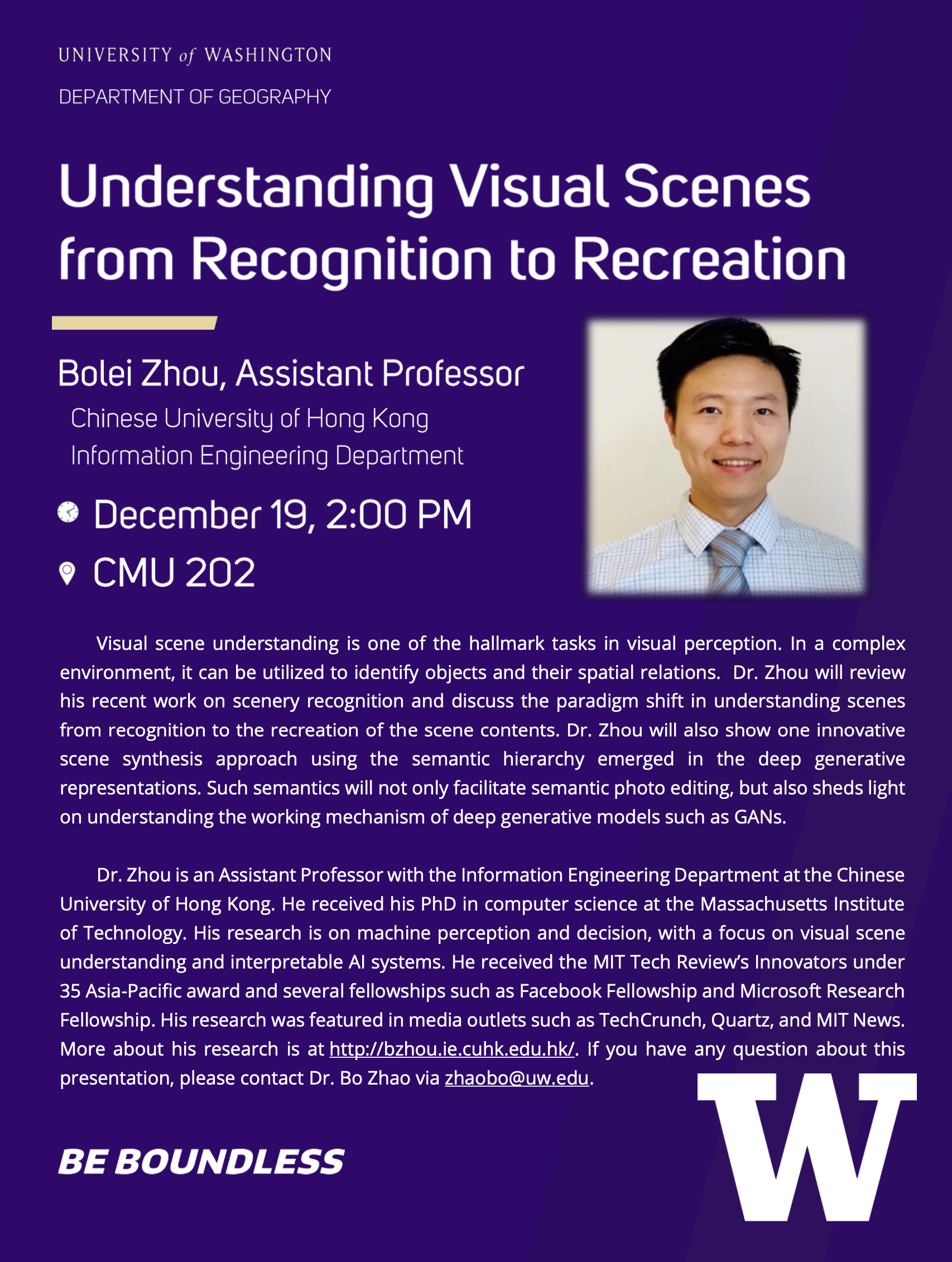
Dr. Bolei Zhou, an Assistant Professor from the Chinese University of Hong Kong, is invited to present his research work at UW. Dr. Zhou has been awarded the MIT Tech Review’s Innovators under 35 in Asia-Pacific. His research is at the intersection of AI and Arts. He has been working on scene recognition and creation using Deep Learning and GANs (Generative Adversarial Networks). His innovative work helps us to better understand the thorny DeepFakes and also shed light on a potential direction in Place-Based GIScience. For more details of his work, please visit http://bzhou.ie.cuhk.edu.hk/.

Dr. Zhou’s visit schedule can be accessed here, and if you want to meet Dr. Zhou individually, there are three open time slots (30 minutes each) from 3:30 to 5:00 PM at SMI 409. For more info about this event, please contact Dr. Bo Zhao via zhaobo@uw.edu.

Undergraduate Student Research Assistant Recruitment

The HGIS lab plans to recruit several student volunteers for an ongoing project to understand how TikTok (a social media video app) serves as an emotional care space for Chinese older people. The completion of this project highly relies on collecting social media data from TikTok, analyzing, and visualizing such a big dataset, and finally, we hope to draw meaningful insights from the empirical study.

The project is currently recruiting undergraduate research assistants to help with data gathering and data analysis. While helping with this project, volunteers will also learn web crawling and hone skills in geospatial big data analysis. Moreover, you will learn how to make sense of social media data using social and critical theories.

The student volunteers need to work with us for 3 hours per week for at least 6 weeks. The professor/supervisor will provide necessary guidance related to data collection, processing, and data visualization. Meeting between the professor/supervisor and the volunteers will be held irregularly based on the project progress and the requests from the students. Ideally, we hope the candidates will have some prior experience in web crawling and python programming. Students who can speak Mandarin are preferred due to the topic of this project is relevant to a Chinese context.

If you are interested in this research opportunity, please contact Dr. Bo Zhao via zhaobo@uw.edu for more information.

“GIScience in the Post-Truth Era” Session at the Denver AAG

The word “post-truth” was named the 2016 Word of the Year by Oxford Dictionary due to its spiking appearance in social media and news coverage of the Brexit referendum and the U.S. presidential election. While the ramifications of post-truth have focused on social, political, and ethical concerns, the issue advocates for a new and critical view of spatial information, especially the fake spatial information in social media (e.g. Facebook check-in, geotagged tweet, location-based review).

The inconsistency between the fake spatial information and the corresponding true location raises a broad set of questions. Can we perceive the inconsistence in the frame of established geographic laws? Are there new laws yet to be explored? As fake spatial information is created intentionally, can the inconsistence be viewed based on our knowledge of error and uncertainty in spatial data? When the fake spatial information goes viral in social media, how does it disseminate over space and time? Ultimately, must all fake be eliminated? The issue demands a much richer context, such as social, political, cognitive, linguistic, and behavioral perspectives to its understanding. The true-fake dichotomy may not even begin to capture the complexity and rich context of the spatial information in social media. Multi-facet societal implications of fake spatial information are yet to be explored.

Confronted with these new challenges, we held sessions at last year’s AAG, that drew large attendance and stimulated lively discussions. We will continue to host sessions at the Denver AAG, and invite GIScientists and other geographers to join the discussion. Topics might include (but not necessarily restricted to):

  • Rethinking of ground truth, spatial data quality, and uncertainty under the context of post-truth.
  • Fake location detection, proof of location and/or other countermeasures using innovative GIS methods.
  • The spatial dissemination of fake spatial information.
  • Critical views of fake locational information (e.g., check-in, geo-tag, location-based review, etc.) and its impacts on geo-privacy, policing, surveillance, and digital governance.
  • Case studies of spatial information falsification (e.g., location spoofing, check-in hacking, satellite image forgery, etc.) and its relevance in public health, national security, and everyday life.

If you are interested in presenting a paper in this organized session, please send your name, affiliation, paper title, and abstract (approximately 250 words) to Bo Zhao at zhaobo@uw.edu by October 25, 2019.

Organizers:

  • Bo Zhao, University of Washington
  • Ling Bian, University at Buffalo

2020 AAG Annual Meeting, Denver, Colorado, April 6-10, 2020